
Page 13 - Green knowledge 2024
P. 13
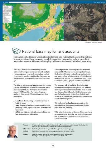
Photo: Kilden.nibio.no; © Geovekst
National base map for land accounts
Norwegian authorities are working to establish local and regional land accounting systems.
In 2024, a national base map was compiled, integrating information on land cover, land
use, and ecosystems. This map will simplify and harmonize the work with land accounting.
Until 2024, no such consolidated map dataset
existed for Norwegian land areas. Instead, multiple
overlapping maps were used, making land analysis
unnecessarily complex. Additionally, there were no
comprehensive ecosystem map with national cover-
age.
The effort to merge several map datasets into a single
national base map is a collaboration between Statis-
tics Norway (SSB), the Norwegian Environment
Agency, NIBIO, and the Norwegian Mapping
Authority (Kartverket). The most important data
sources are:
•
•
•
Land use, documenting how land is utilised in
built-up areas.
AR5, displaying land resources in municipalities,
including forests, agricultural land, peatlands, and
open land.
AR50 and N50, providing less detailed informa-
tion on areas above the treeline.
“The compilation is now complete, and the results
are available. The map shows, among other things,
the location of forests, peatlands, agricultural land,
and water bodies. In built-up areas, it highlights resi-
dential zones, schools, and commercial areas,” says
Geir-Harald Strand, project coordinator at NIBIO.
The base map will be useful for developing land
accounts in Norwegian municipalities and counties,
allowing for the documentation of the effect of land-
use changes. Kjersti Bakkebø Fjellstad, project man-
ager for land accounts in Akershus, Østfold, and
Buskerud, is pleased that the base map is now acces-
sible to all municipalities.
“To implement land and nature accounts at the
municipal level, having this foundational data in
place is crucial,” she says.
“This is the first version of the map. Many users have
provided valuable feedback, and some improvements
will be made before it enters routine production,”
concludes Strand.
Purpose: Collaboration: Funding: Contact: Create a national base map for land accounting. This work saves society costs by eliminating the
need for each municipality to perform the same task independently.
Kartverket, Statistics Norway, and the Norwegian Environment Agency.
Kartverket, Norwegian Environment Agency, Statistics Norway and NIBIO.
Head of Research Geir-Harald Strand, Division of Survey and Statistics.
Email: geir.harald.strand@nibio.no | Phone: +47 415 01 640
11
