
Page 46 - Green knowledge 2024
P. 46
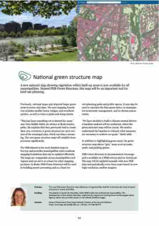
Photo: Kathrine Torday Gulden
National green structure map
A new national map showing vegetation within built-up areas is now available for all
municipalities. Named FKB-Green Structure, this map will be an important tool for
land-use planning.
Previously, national maps only depicted larger green
areas in towns and cities. The new mapping founda-
tion includes smaller lawns, hedges, and woodland
patches, as well as trees in parks and along streets.
“This has been something we’ve desired for years,”
says Vesa Heikki Jäntti, an advisor in Bodø munici-
pality. He explains that they previously had to create
their own overviews of green structure for each revi-
sion of the municipal plan, which was time-consum-
ing. The new green structure map will simplify these
processes significantly.
The FKB dataset is the most detailed maps in
Norway and provides municipalities with a uniform
mapping foundation that can be updated efficiently.
The maps are comparable across municipalities and
regions and can serve as a basis for other mapping
products. In Bodø, FKB-Green Structure will be used
in building permit processing and as a basis for
sub-planning parks and public spaces. It may also be
used to calculate the blue-green factor, in strategies
for stormwater management, and in climate assess-
ments.
“We have decided to build a climate-neutral district.
A baseline analysis will be conducted, where the
green structure map will be crucial. We need to
understand the baseline to evaluate what measures
are necessary to achieve our goals,” Jäntti adds.
In addition to highlighting green areas, the green
structure map shows “grey” areas such as roads,
yards, and parking spaces.
FKB-Green Structure is documented in Geonorge
and is available as a WMS service and for download.
The map will be updated annually with new FKB
data and periodically every three years based on new
high-resolution satellite imagery.
Purpose: Funding: Contact: The new FKB-Green Structure map addresses a long-standing need for more accurate maps of green
structures in towns and cities.
The dataset is owned by Geovekst, while NIBIO holds the professional responsibility. The
development of the dataset has been supported by Copernicus funding from the Norwegian Space
Agency, which also provides access to the utilised satellite images
Head of Department Tove Vaaje-Kolstad, Division of Survey and Statistics.
Email: tove.vaaje-kolstad@nibio.no | Phone: +47 930 08 377
44
